Andre Howson
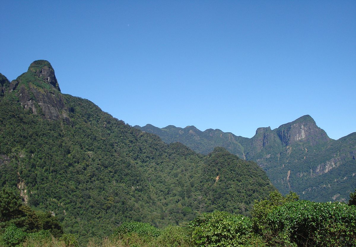
When one thinks of travelling in Sri Lanka, the first thing that comes to mind is its beaches. And we do have good beaches. But what’s less well-known is Sri Lanka’s amazing hill country. Mostly concentrated in the Central Province, the higher elevations of the island provide a very different environment to the rest of the country. We’re not referring to Kandy or Nuwara Eliya or the usual tourist hotspots that people run to, to escape the summer heat, but country that is significantly hillier.
There are plenty of hiking trails for the casual traveller. Places like Horton Plains and Ella offer a great experience for everyone without being too physically strenuous. But if you like your trails a bit tougher, more exotic, and a lot less crowded, then the Knuckles range of mountains spanning the districts of Kandy and Matale is probably the best place you could find. So called because the folds and peaks look like the knuckles of a closed fist, the mountain range is largely untouched and very beautiful.

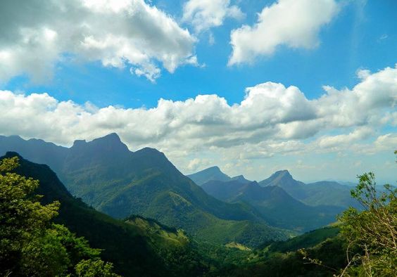
The Knuckles Mountain Range: Image courtesy Coconut Tours
Knuckles covers just 0.03% of the island’s area, but is home to several major forest formations and a significant concentration of the country’s biodiversity.
It’s very popular among a small community of local hiking enthusiasts who have their own favourite trails and camping sites across the range, as well as among a subset of tourists who prefer being active to turning orange on a beach. However, it’s still not one of the most popular holiday destinations on the island—at least not till recently, when more and more tour guides have been setting up shop.
It’s also far out of the way, which makes it unsuitable for a spur-of-the-moment road trip. The mountain range is almost 180 km from Colombo, which can mean a six-hour drive or more, especially with bad traffic near Kandy.
Making Plans
There are many ways to get to the Knuckles range, but we took the route through Kurunegala, past Kandy and Digana, and ended up at Udispattuwa, where we stayed the night.
Since there are so many trails in Knuckles, getting information on a particular one can be difficult. Some trails that will be suggested to you by hotels or guides go across the range of mountains, while others use roadways and cross villages without reaching any sort of significant elevation. Any hotel you call will tell you that you most certainly can climb Knuckles from their location and they have plenty of experienced guides waiting to take you. But you’ll need to decide exactly what kind of hike you are looking for, and do some research before accepting any route suggested to you. You’ll have to decide whether you want to see villages, visit waterfalls, just experience the general area, climb a peak, camp, or do a combination of them. After that, you can talk to your hotel or guide to organise it. You could also do your own research using the trip reports posted on Lakdasun, a local crowd-sourced travel website.
Initially, we wanted to climb all five peaks of the range, but it was hard to find enough information about trails and starting points. The manager of the hotel we settled on was quite knowledgeable about trails around the range, but even he couldn’t tell us how we could cover all five peaks. This may have been because we were at the wrong end of the range. We found out later that we would have had to start further north, from Bambarella, to reach the first of the peaks. You can expect a lot of miscommunication, depending on what you want to do, and who you travel with.
He did get us a guide from the village, though, who managed to take us up the tallest of the peaks in the range.
On Guides
There are dozens of tour services that plan treks and camping across the ranges. These can be a tad expensive, though worth it sometimes, for the security it offers. We almost wanted to do it without a guide, being wary of being ripped off, but the manager (who also used to be a guide) told us horror stories of injured hikers and broken legs. He told us he once had to carry a 40-year-old German lady, who had broken her ankle, all the way back down a mountain to its base. We relented and accepted a guide. He advised two, but we settled for one local guide. At Rs. 2,000 for a day’s work, they’re not exactly the cheapest.
The Trek
From Udispattuwa, we had to drive north up Rangala road. After about 8 km, past the Duckwari Tea Factory, the road branches. We took the path heading east, which eventually led to tea estates and the edge of the forest. The roads are really bad and pretty winding, so a vehicle with high clearance is a must, because it really messes with the shocks of your car. Alternatively, you could take a tuk tuk, because physics don’t seem to apply to tuk tuks.
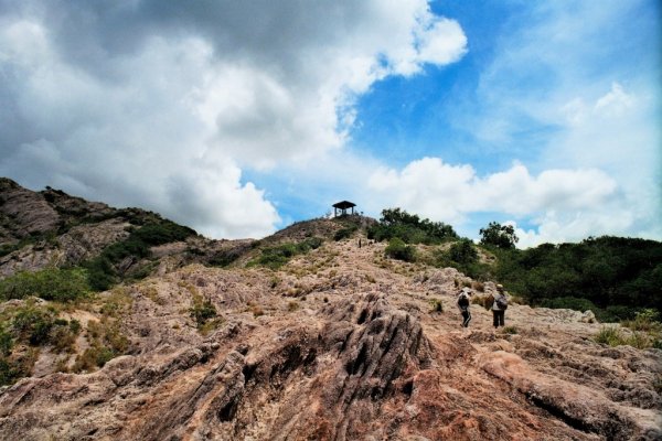
At the edge of the range, we parked the car at a small school and started the climb. The first bit of the hike was through a tea estate, and it quickly became apparent why we needed a guide. For one, there was no way we’d have been able to find our way without him. There were far too many paths to figure out which one was right. Also, halfway through the estate, the altitude started messing with one of our group. She had trouble breathing, developed a wheeze, and had to head back to the car. This was why the manager had suggested two guides, so that one could lead on, while the other took care of anyone who succumbed to injuries. A kilometre uphill later, we asked for a break, and the guide informed us that we hadn’t even reached the edge of the range yet; we’d just gotten past the estate. The guide was a wizened old man in rubber slippers and shorts. Unlike the rest of us, he wasn’t even short of breath.

The trails are bordered by trees, and often have mist rolling in. Image credit: Cheryl Howson
From this part of the trail, the tea plantation gave way to a low forest, with a marked change in vegetation and temperature. The air here was so fresh, you felt like bottling it and bringing back to sell at the Good Market. Another kilometre or so into the forest, we came to an open flat area on top of a hill. We had our breakfast here, as the mist rolled in. Diverging from the path here led to a waterfall, which was an easier hike, but we decided to continue through the forest.
The climb was very beautiful. The Knuckles mountain range is the one place in Sri Lanka where you come across all types of forests, from dry grass sloping down the sides of the mountain, to waterfalls and mist-laden cloud forests. By the time we were two-thirds the way to the peak, the humidity had increased and a thick mist was rolling in over the peaks again. We crossed streams with ice cold water flowing by, climbed over tree trunks fallen across the path, and dodged dragonflies.

Streams often cross the trail. Image courtesy writer
There’s an impressive collection of fauna endemic to Sri Lanka, and found mostly in the forests of the Knuckles range, like the horn-nosed lizards (Ceratophora tennentii), which are almost exclusively found here, and are hard to spot because they are so well-camouflaged. It’s hard to keep pace on the trail when you want to stop and see all the wildlife.

The horn-nosed lizard. Image courtesy writer
If you are not reasonably fit, five or six kilometres steadily uphill can be hell on your knees, but as we came closer to the peak, we realised that things were about to get worse. The trail first widened to a more open, stoney slope with coarse grass that made walking easier, and allowed us to see more than just trees. There was also an old platform that the guide told us was set up nearby for campers. From this point, the last two kilometres were up a hill covered in thick forest, and sloping upwards at a near 45 degree angle most of the time.

The last stretch was an upward climb through a tunnel of trees. Image courtesy writer
We had to leave another of our group behind at this point, because the rest of the trek was gruelling. At the base of the slope, we found the remains of a deer that the guide told us was killed by a leopard. The thought did not inspire much confidence.

Leopard dinner. Image courtesy writer
After we entered a tunnel of trees, it was hands and knees climbing most of the way. That stretch of the hike can be pretty hazardous, especially if it rains heavily. We only had to deal with a light rain, so while we encountered some mud, we did not struggle too much. Here, the guide pulled out his machete and hacked the branches and foliage that had grown into the path. But since he was short, and only cleared the branches at his head-height, it didn’t help us all that much. At this stage, he was breathing slightly harder. We were hyperventilating.
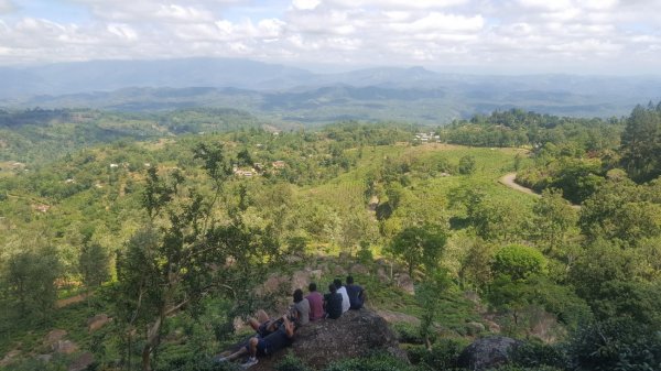
Two torturous kilometres later, we were at the peak. This highest peak in the range (called Gombaniya) is about 1864 m above sea level. The view can be a bit hit or miss. At one point breath-taking, and at the other, completely covered by mist. But it is absolutely worth it. The sense of achievement that comes from reaching the top of a mountain is incredible. It’s a high (pun intended) that beats anything chemicals can do for you.
But there’s only so long one can stay up there before hunger drives you back down, especially when the hotel has promised you the best pol roti you’ve ever eaten.
You’d think that going down is easier than going up, but it’s just a whole different set of muscles that start aching. The entire hike was barely over 14 km, but the difficulty level of the slopes slowed us down some. If you’re in moderately good shape, you could do it in seven hours. Either way, we made better time on the way back. Pol roti never tasted so good.
Be Prepared
If you have a good sense of direction, enough experience, and are properly prepared, you could do the hike without a guide. But it was much easier for us with one. There are probably several starting points and paths to get to the top of the peak, and each guide may take you a different way.
When you do hike through the range, carry plenty of water and some food. You can get dehydrated pretty quickly, and you’ll definitely appreciate the food. Also, don’t leave any plastics behind. It’s best not to take any at all. Climbing sticks help with the slopes, and wear comfortable clothing, because chafing in awkward places can get pretty uncomfortable over several kilometres. But the biggest thing you need to prepare for, is the leeches. They’re everywhere. They reach out to you from the ground as you walk past, waving around like little alien tentacles, hungry for blood. The first few kilometres, the treetops resounded with squeals as we stopped often to de-leech. But we got used to it after a while and plucked them off while on the go, because the moment we stopped to get rid of them, the easier we realised it was for others to latch on to you. The general wisdom is to carry salt to get leeches off your skin, but we found great success with a solution of Dettol. They drop off when doused with it far more effectively than with salt, though with the unfortunate side effect of disgorging all the blood they drank on you. It can get messy. An even better defence was leech socks, which can be laced up all the way to your knees, and which were impossible for the leeches to worm through. Most of us did get bitten, however. Bites can take weeks to heal, but otherwise are not really dangerous or painful, except for an annoying itch.
Gombaniya is just one place of several places to visit in the area. There’s no way you can cover all of it in a trip or three, but it is certainly fun to try. Knuckles is a UNESCO World Heritage Site and a tremendously beautiful place to visit. It’s hard to describe the freshness of the air, the greenness of the hills, and the vigour of being among the mountains. You’re surrounded by so much life, that it’s almost impossible to believe. You could spend days just exploring one trail and observing all the wildlife in it. It’s not an experience one can forget anytime soon.
Editor’s note: The peak our writer referred to was earlier incorrectly identified as “the second knuckle” in the range. This has now been corrected to the “tallest peak” in the range. We apologise for the confusion.
Tickets and information on managed trails in the Knuckles range and forest reserve can be obtained from the forest department offices at Deanston and Illukkumbura. More information and a trail list can be found on their website.
Featured image courtesy wikipedia